Weather Service: Threat of hurricanes impacts all Alabamians
Published 8:46 pm Friday, May 31, 2013
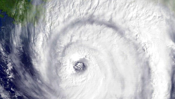
A satellite image shows Hurricane Ivan as it approached the central Gulf Coast in September 2004. Many in Alabama remember Ivan’s arrival as it ripped its way through Alabama, causing millions of dollars in damage throughout the state.
There’s always talk about the passing of the seasons. There’s the transition of spring to summer, summer to fall and so on. There’s the always much-anticipated start of college football season.
But Saturday marks the start of a season many along the Alabama Gulf Coast dread each and every year — and a season many throughout the state should mark on their calendar and prepare for.
From June 1 through the end of November, the eyes of those living in a large portion of the United States begin focusing a little more closely on the tropics and updates on possible developments of tropical storms and hurricanes.
Saturday marks the beginning of the Atlantic hurricane season and forecasters said the 2013 season could be a little more active than normal.
“This year, oceanic and atmospheric conditions in the Atlantic basin are expected to produce more and stronger hurricanes,” said Gerry Bell, Ph.D., lead seasonal hurricane forecaster with NOAA’s Climate Prediction Center. “These conditions include weaker wind shear, warmer Atlantic waters and conducive winds patterns coming from Africa.”
Bell’s comments were part of a Prediction Center release last week that said the upcoming hurricane season could see as many as 13 to 20 named storms, with seven to 11 of those storms becoming hurricanes. Further, the center said three to six of those storms could develop into major hurricanes, which are storms reaching Category 3 level or stronger.
“While these forecasts do use good models and a number of variables, it remains a prediction and it could be less or more,” Birmingham National Weather Service office meteorologist Matt Anderson said. “It’s important that residents continue to pay attention to the forecasts.”
Now while Selma is in the heart of the Black Belt, hours away from the nearest beach, that doesn’t mean the impacts — the potentially deadly impacts — cannot be felt here.
“Even though you might not have the landfall — the direct impact — the area has the potential to receive the tornadoes that are spun off, the continued high winds, the downed trees and power outages,” Anderson said. “There’s plenty of history — from Katrina, Ivan and others — to show those in the northern areas of Alabama that a hurricane doesn’t have to impact the area directly to do damage.”
Anderson also said the nature of hurricanes makes predicting the occurrence and direction of tornadoes created by hurricanes is even harder.
In their annual Preparedness Guide, the National Oceanic and Atmospheric Administration offered a number of tips to residents to prepare for the season, including: learn the location of official shelters, determine safe evacuation routes further inland, check emergency kit, buy food that will keep, trim trees so branches don’t fly into your home and review your insurance policy.
The full guide can be found at www.nhc.noaa.gov/prepare.